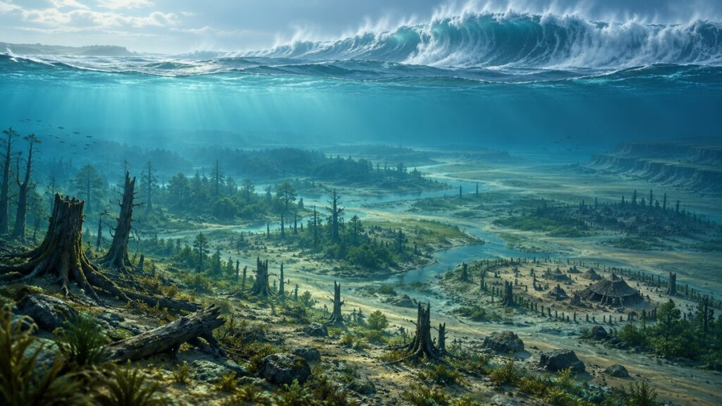
No single tsunami permanently swallowed Doggerland. The Storegga Slide off Norway did generate a powerful tsunami about 8,150 years ago, and some North Atlantic coasts were hit hard. But by then, rising seas had already broken Doggerland into islands, banks and coastal remnants. The tsunami water receded; continuing sea-level rise later submerged the land that remained.
That distinction matters because the popular image—a complete country erased by one enormous wave—does not match the best-supported archaeological and modelling evidence. The event was real and locally devastating, yet its effects depended on the shape of the seabed, the height of surviving ground and the location of each community.
What Doggerland was before the tsunami
Doggerland was a broad, low-lying landscape beneath today’s southern North Sea. During the last Ice Age, when global sea level was much lower, it connected Britain with continental Europe. Rivers, wetlands, lakes, woodland and dry plains occupied what is now seabed. Mesolithic people hunted, fished and moved through this territory, leaving behind tools, animal remains and other traces that have sometimes been recovered by dredging or underwater investigation.
It was not a permanent island with a single shoreline. As ice sheets melted after the Ice Age, sea level rose and the coastline migrated inland. Estuaries expanded, low areas flooded and the continuous land bridge became a patchwork of peninsulas and islands. Reconstructions based on palaeobathymetry—the study of ancient seafloor shape—and sea-level curves suggest that by about 9,000 calibrated years before present, Doggerland had become an archipelago rather than the intact landmass often shown in illustrations.
Quick wins for a faster PC:
Repair Windows errors before they cause bigger problemsFix Now →Fix the driver behind crashes, sound loss and screen glitchesFind Drivers →#1 Best Overall

- Read Before You Buy — No Video Output: These adapters support charging and USB 2.0 data transfer, but cannot transmit video signals. Except for standard USB webcams (which use USB data only), they are not compatible with HDMI/DisplayPort cables, video-capable USB-C hubs, or docking stations with video output.
- Convert USB-A Ports to USB-C: Designed to connect USB-C earphones, cables, flash drives, card readers, and other USB-C accessories to standard USB-A ports. Plug-and-play with no drivers or software required.
- Aluminum Alloy Housing: Built with a sturdy aluminum alloy shell that aids in heat dissipation and protects against daily wear and scratches. Designed to maintain a stable and secure connection.
- Compact & Travel-Friendly: The ultra-compact design allows the adapter to stay plugged into your device without blocking adjacent ports or adding bulk, reducing wear and tear on your original USB ports.
- 12-Month Warranty: Backed by a 12-month manufacturer warranty for peace of mind. Designed to meet strict quality control standards for reliable everyday performance.
By the time of the Storegga event, the Dogger Island area may have been reduced to a shallow bank with a smaller high-ground remnant. These coastlines are estimates, not photographs of a directly observed shoreline, so maps showing a precise outline should be treated as explanatory models rather than exact borders.
A landscape already under pressure
Sea-level rise did more than move the coast. It changed drainage, soils, freshwater access, animal habitats and travel routes. A settlement that had been inland could become coastal, tidal or periodically isolated. Communities could relocate gradually as familiar ground disappeared. This long transformation is central to explaining why abandonment cannot automatically be attributed to one disaster.
What the Storegga Slide was
The Storegga Slide was a huge submarine landslide on the margin off Norway. Sediment collapsed across a vast area of the seafloor, displacing water and generating a tsunami that travelled through the Norwegian Sea and toward parts of the North Atlantic and northern Europe. Earlier geological work summarized in a 2020 synthesis estimates a slide area of about 80,000 square kilometres and roughly 3,200 cubic kilometres of displaced sediment. Both figures are reconstructions and carry uncertainty about the original failure geometry.
The commonly used age for the tsunami is around 8,150 years ago. A 2024 study of moss fragments associated with onshore tsunami deposits reports a calibrated radiocarbon range of 8,080–8,180 years before present, expressed as 8,140 ± 55 years ago. That result comes from one dated sample context; it should not be treated as a universal timestamp for every deposit attributed to the event.
Recommended Free Tools
Rank #2

- 5-in-1 USB-C Hub: Experience comprehensive connectivity featuring a Power Delivery input, two USB-A 2.0 ports, a USB-A 3.0 port, and an HDMI port. (Note: The USB-C power delivery input port is only for connecting an external wall charger to power your laptop and cannot power peripheral devices.)
- 90W Pass-Through Charging: Achieve optimal charging with 90W pass-through power to your laptop, supported by a total input of 100W, with the hub reserving 10W for operational efficiency. (Note: Wall charger not included.)
- Quick Data Transfers: Accelerate your productivity with rapid data transfers using a high-speed 5Gbps USB 3.0 port and two 480Mbps USB 2.0 ports.
- 4K HDMI Display: Enhance your visual experience with a hub capable of delivering 4K resolution at 30Hz in both mirror and extend modes. Please note that this hub is compatible with MacBook (macOS 12 and newer), Windows 10 and 11, ChromeOS, and laptops equipped with DP Alt Mode and Power Delivery. Note: This device is not compatible with Linux.
- What You Get: Anker USB-C Hub (5-in-1, 4K HDMI), welcome guide, 18-month warranty, and our friendly customer service.
Evidence that a tsunami reached land
Geologists identify tsunami deposits by looking for marine sand or shell material carried inland, abrupt sediment layers, rip-up clasts and other features that ordinary tides or storms are less likely to produce. Deposits and run-up evidence have been reported from several North Atlantic and northern European locations. The 2020 archaeological review also discusses offshore evidence from the southern-central North Sea, strengthening the case that the wave reached the region associated with late Doggerland.
One frequently cited estimate is up to about 20 metres of run-up on Shetland. Run-up is the maximum vertical height water reaches above the undisturbed sea surface on a shore; it is not the same as offshore wave height, and it does not describe conditions across Doggerland. A high value on exposed Shetland cannot be applied automatically to the shallow southern North Sea.
Did the tsunami permanently flood Doggerland?
On the evidence currently available, no. The wave could have inundated, eroded or contaminated parts of the remaining landscape, and people in exposed locations may have suffered severe losses. But tsunami water is transient: after arriving, it flows back toward the sea. Walker and colleagues’ 2020 synthesis concludes that the event was neither universally catastrophic nor the final flooding event for the Dogger Bank or the Dogger Littoral.
The more likely sequence is cumulative. Sea-level rise had already fragmented the terrain. The tsunami then struck a complicated mosaic of shallow banks, channels and islands. Water may have crossed some low ground, scoured shorelines and deposited marine sediment, while higher remnants or areas behind the Dogger Bank experienced less direct flow. Afterward, the continuing rise in sea level submerged the remaining exposed ground. In this interpretation, the tsunami was an important shock within a longer coastal transformation, not a single wave that left the entire region permanently underwater.
What’s actually slowing this PC down?
Pick the symptom - the matching free tool is one click away.
Rank #3

- Sleek 7-in-1 USB-C Hub: Features an HDMI port, two USB-A 3.0 ports, and a USB-C data port, each providing 5Gbps transfer speeds. It also includes a USB-C PD input port for charging up to 100W and dual SD and TF card slots, all in a compact design.
- Flawless 4K@60Hz Video with HDMI: Delivers exceptional clarity and smoothness with its 4K@60Hz HDMI port, making it ideal for high-definition presentations and entertainment. (Note: Only the HDMI port supports video projection; the USB-C port is for data transfer only.)
- Double Up on Efficiency: The two USB-A 3.0 ports and a USB-C port support a fast 5Gbps data rate, significantly boosting your transfer speeds and improving productivity.
- Fast and Reliable 85W Charging: Offers high-capacity, speedy charging for laptops up to 85W, so you spend less time tethered to an outlet and more time being productive.
- What You Get: Anker USB-C Hub (7-in-1), welcome guide, 18-month warranty, and our friendly customer service.
What different studies conclude
Disagreement is not about whether a Storegga tsunami existed. It concerns how much land remained, how water moved across it and what “catastrophic” should mean. The following comparison shows why apparently conflicting headlines can arise.
| Interpretation | Reconstructed land at the event | Main impact measure | What it implies | Important limitation |
|---|---|---|---|---|
| Earlier catastrophic scenarios | A relatively substantial, exposed Doggerland or Dogger Island | Large modelled flooding and rapid destruction | A single event could have wiped out communities and most remaining land | Results depend strongly on assumed ancient bathymetry, sea level and slide dynamics |
| Hill and colleagues, 2017 numerical model | A landscape already reduced by rapid sea-level rise | Modelled inundation under alternative seabed and slide inputs | Less flooding than some earlier scenarios; sea-level rise was probably the primary cause of abandonment | It is a simulation, not a direct measurement; uncertain input reconstructions affect the outcome |
| Walker and colleagues, 2020 archaeological synthesis | A fragmented archipelago, with the Dogger Island area possibly reduced to a shallow bank and a smaller high remnant | Deposits, topography, landscape history and archaeological context | Severe impacts in some places, but not universally catastrophic and not the final submergence | The exact coastline, population and local damage remain difficult to quantify |
These interpretations can all contain useful information when their spatial scale and assumptions are kept separate. A model of peak inundation in one embayment is not a measurement of the entire North Sea, and evidence from northern islands does not automatically describe the southern basin.
Why location changed the outcome
North Atlantic and island coasts
Coasts directly exposed to the incoming wave could receive much higher run-up than sheltered shallows. Steep or open shorelines can focus energy, while headlands, reefs and irregular channels can redirect it. The Shetland estimate of up to about 20 metres illustrates the potential for extreme local run-up, not a uniform regional wall of water.
The shallow southern North Sea
Doggerland occupied a very shallow, changing sea. The seabed contained banks and channels, and the surviving high ground may have acted as a partial barrier. The Dogger Bank could have sheltered some locations while concentrating currents and erosion around others. A wave entering a shallow basin can lose energy through friction, but shallow water can also increase flow depth and push water farther across low terrain. Which effect dominated depended on the exact ancient topography.
Rank #4

- Dual Converters, Infinite Potential:Includes 2× USB C male to USB A female adapters and 2× USB A male to USB C female adapters. Perfect for a wide range of uses—tablets with Bluetooth keyboards, expand USB ports on macbook, and more. Two different converters for all your daily needs
- Next-Level 10Gbps & 3A Charging: No more slow 480Mbps, this usb to usb c adapter has a transfer speed of up to 10Gbps, allowing you to do more transferring in less time. This usb adapter fits both USB A and USB C charger, supporting up to 3A fast charging
- Upgraded Exquisite Craftsmanship: With an aluminum alloy housing and metal connector, the usbc to usb adapter is extremely durable and sturdy. Rigorously tested to withstand more than 10,000 times of plugging and unplugging, ensuring long-lasting performance
- Broad Compatible: The usb c to usb adapter widely supports all USB C/ USB A devices like laptops, tablets, cellphones, car chargers, and phone chargers. Such as compatible with MacBook Pro/Air 2023/2022, Thunderbolt 4/3 Devices,Apple MagSafe Watch 9/8/7/SE/Ultra, iPad Pro 2022/2021, Samsung Galaxy S23/S20/S10, and iPhone 17/16/15 Pro. Plug and play
- Please Note: To reach 10Gbps speed, keep the cable under 3.3 ft. For USB A Male to USB C adapters, try flipping the USB C connector. USB C Male to USB A adapters support bidirectional 10Gbps transfer within 3.3 ft
Temporary flooding versus permanent submergence
Reports may use “flooding” for several different measurements: peak water depth, inland inundation distance, erosion, sediment transport or the later loss of land to rising seas. Those are not interchangeable. A brief surge over a settlement, a channel cut through a bank and a coastline permanently moved inland are separate processes that can occur in the same region at different times.
A timeline of Doggerland’s transformation
| Approximate date | What was happening | Why it matters |
|---|---|---|
| After the last Ice Age | Melting ice raised global sea level and progressively flooded low plains between Britain and mainland Europe. | The land bridge began changing long before the Storegga tsunami. |
| By about 9,000 calibrated years before present | Reconstructions indicate an archipelago of islands and remnants rather than one continuous plain. | Any tsunami impact occurred on a fragmented landscape. |
| Around 8,150 years ago | The Storegga Slide generated a tsunami in the North Atlantic and northern European region. | Some exposed coasts experienced severe inundation and erosion. |
| 8,080–8,180 calibrated years before present | A 2024 dated moss-fragment context falls within this range for an onshore tsunami deposit. | It provides a precisely reported sample age, not a date for every deposit. |
| After the tsunami | Sea level continued rising and submerged the remaining Doggerland high ground. | Long-term drowning, rather than a permanent tsunami surge, finished the landscape’s disappearance. |
What happened to the people?
Mesolithic communities lived in and around the North Sea basin, but no reliable total population for Doggerland has been established. The available studies also do not provide a dependable death toll or percentage of people killed by the tsunami. Claims that a known number of thousands died, or that an entire population was wiped out, go beyond the evidence.
That uncertainty does not make the human consequences trivial. A tsunami can destroy boats, camps, food stores and fishing equipment; contaminate freshwater; strand people on shrinking islands; and disrupt seasonal routes. Survivors could move to higher ground or mainland coasts, but those destinations may already have been occupied or under environmental stress. Archaeological silence is especially difficult to interpret underwater: tsunami erosion can remove deposits, later sediment can bury them, and much of the relevant landscape is inaccessible beneath the sea.
Independent reader supportYour contribution helps us test, update, and keep practical guides available for everyone.How scientists test the competing explanations
Reconstructing the ancient seabed
Researchers combine seismic surveys, cores, sediment samples and modern bathymetry to estimate the shape of the former land surface. They then remove or account for later sedimentation and model how rivers, shorelines and tidal channels may have looked. Small errors in a low-relief landscape can change whether a location is treated as dry land, a tidal flat or open water.
Best Value

- 5-in-1 Connectivity: Equipped with a 4K HDMI port, a 5 Gbps USB-C data port, two 5 Gbps USB-A ports, and a USB C 100W PD-IN port. Note: The USB C 100W PD-IN port supports only charging and does not support data transfer devices such as headphones or speakers.
- Powerful Pass-Through Charging: Supports up to 85W pass-through charging so you can power up your laptop while you use the hub. Note: Pass-through charging requires a charger (not included). Note: To achieve full power for iPad, we recommend using a 45W wall charger.
- Transfer Files in Seconds: Move files to and from your laptop at speeds of up to 5 Gbps via the USB-C and USB-A data ports. Note: The USB C 5Gbps Data port does not support video output.
- HD Display: Connect to the HDMI port to stream or mirror content to an external monitor in resolutions of up to 4K@30Hz. Note: The USB-C ports do not support video output.
- What You Get: Anker 332 USB-C Hub (5-in-1), welcome guide, our worry-free 18-month warranty, and friendly customer service.
Applying sea-level curves
Radiocarbon dates, coral and sediment records, and glacial-isostatic models are used to estimate sea level through time. Different curves can place the coastline tens of kilometres apart in a shallow basin. Because Doggerland was already disappearing, the assumed sea level at 8,150 years ago is one of the most consequential inputs in any simulation.
Modelling the slide and wave
Numerical models vary the slide’s volume, speed, direction and failure stages, then calculate wave propagation across reconstructed seas. The 2017 modelling study found less inundation under its preferred scenarios than some earlier work, while also emphasizing uncertainty in palaeobathymetry and slide characteristics. A model result should therefore be read as a physically tested scenario, not as a camera recording of the event.
Matching deposits to an event
Field teams compare grain size, microfossils, chemical signatures and stratigraphic position. A deposit is more convincing when its age, direction of transport and sediment characteristics fit a tsunami and when alternative explanations such as storms or river floods are less plausible. Even then, one outcrop records local conditions, not the whole region.
Common misconceptions to avoid
- “One wave swallowed all of Europe.” The tsunami affected parts of the North Atlantic and northern Europe; it did not submerge an entire continent.
- “Doggerland was intact when the wave arrived.” Evidence-based reconstructions show substantial fragmentation before the Storegga event.
- “The 20-metre figure is Doggerland’s wave height.” It is an estimate of run-up on Shetland, under different coastal conditions.
- “The tsunami permanently raised sea level.” A tsunami temporarily displaces water. The later, sustained rise in sea level caused permanent submergence.
- “Archaeologists know how many people died.” No authoritative population total or death toll has been established.
- “No tsunami deposit means no tsunami.” Erosion, burial, underwater location and limited sampling can all erase or hide evidence.
Why the corrected story matters
Doggerland is a case study in how disasters interact with gradual environmental change. A sudden wave can be dramatic without being the sole cause of a society’s relocation. Conversely, a slowly rising sea can be socially disruptive even when no single day appears in the archaeological record as the moment of collapse.
The Storegga tsunami therefore belongs in a layered explanation: a real submarine landslide, a real regional tsunami, highly uneven local damage and a coastline already being transformed by sea-level rise. As Walker and co-authors wrote in their 2020 conclusion, “The impact of the tsunami was highly contingent upon landscape dynamics, and the subsequent rise in sea level would have been temporary.” That is a more precise—and more revealing—answer than the image of one wave erasing a finished country.
Quick Recap
Product prices and availability are accurate as of the date/time indicated and are subject to change. Any price and availability information displayed on Amazon at the time of purchase will apply.






Say something about this film