Recommended Free Tools
A hurricane is an official tropical-cyclone classification; “megastorm” is not. In the Atlantic and eastern Pacific, the National Hurricane Center (NHC) classifies a tropical cyclone as a hurricane when its maximum sustained surface winds reach at least 74 mph (64 knots). “Megastorm” is informal descriptive language for a storm that is exceptionally powerful, broad, disruptive or unusual. It has no NHC wind threshold, category, warning product or fixed meaning.
That distinction matters because a label cannot tell you how much rain will fall, how far the wind field extends, whether coastal water will rise, or what conditions will occur at your address. A hurricane can be called a megastorm, but the word does not automatically mean that it is stronger than every hurricane. Use measured winds, the storm’s size and speed, hazard-specific forecasts, and local emergency instructions to judge risk.
What is the difference between a hurricane and a megastorm?
The terms describe different things. Hurricane is a formal classification used by the NHC for a tropical cyclone with maximum sustained surface winds of 74 mph (64 knots or 119 km/h) or more. It is one stage in a recognized classification sequence that also includes tropical depression, tropical storm and major hurricane.
Megastorm is a popular, nontechnical description. Official material does not establish it as a separate NHC category or assign it a wind-speed cutoff. NOAA has used the word retrospectively when discussing Sandy, whose broad wind field and interaction with Arctic air produced unusually extensive effects. That usage illustrates the word’s descriptive purpose; it does not create a formal definition.
Quick wins for a faster PC:
Clear out junk files and repair common Windows errorsFree Scan →Fix the driver behind crashes, sound loss and screen glitchesFind Drivers →Repair Windows errors before they cause bigger problemsFix Now →#1 Best Overall

- HD streaming made simple: With America’s number 1 TV streaming platform,* exploring popular apps—plus tons of free movies, shows, and live TV—is as easy as it is fun. *Based on hours streamed—Hypothesis Group
- Compact without compromises: The sleek design of Roku Streaming Stick won’t block neighboring HDMI ports, and it even powers from your TV alone, plugging into the back and staying out of sight. No wall outlet, no extra cords, no clutter.
- No more juggling remotes: Power up your TV, adjust the volume, and control your Roku device with one remote. Use your voice to quickly search, play entertainment, and more.
- Shows on the go: Take your TV to-go when traveling—without needing to log into someone else’s device.
- TV, simplified: With setup that only takes minutes, a simple-to-navigate Home Screen, and an uncluttered remote control that does all you need—Roku makes it easier to watch the TV you love.
Consequently, “hurricane versus megastorm” is not a comparison of two levels on one intensity scale. One term identifies a meteorological classification. The other emphasizes an impression of exceptional size, reach, damage or complexity. A hurricane may be described as a megastorm, while a storm described informally as a megastorm could have very different wind, rain and surge characteristics from another storm given the same label.
Is a megastorm worse than a hurricane?
Not necessarily. “Worse” depends on the hazard and the location. A hurricane with a compact but intense wind core may be more dangerous for structures near its eyewall than a larger storm with lower peak winds. Conversely, a broad system can push dangerous water and tropical-storm-force winds over a much larger area, or deliver prolonged rain far inland. The word megastorm does not settle that comparison.
Is megastorm an official weather term?
No. The NHC’s formal classification references use tropical depression, tropical storm, hurricane and major hurricane. “Megastorm” appears as narrative language in descriptions of exceptional events, not as a warning category or intensity measurement. Treat it as a headline or explanatory adjective, not as a technical forecast product.
How the official hurricane classification works
Hurricane threshold
The NHC uses maximum sustained surface wind to identify a hurricane. The threshold is 74 mph (64 knots) or higher. Sustained wind is an average wind measurement over a stated period, rather than the speed of an individual gust. The threshold tells you that the cyclone has reached hurricane strength; it does not predict the exact damage at every location.
Major hurricane threshold
A major hurricane has sustained winds of at least 111 mph (96 knots). This corresponds to Category 3, 4 or 5 on the Saffir-Simpson Hurricane Wind Scale. Categories estimate the potential for wind damage from the sustained wind value. They do not summarize storm surge, rainfall, tornadoes, rip currents or the total area affected.
Rank #2

- Ultra-speedy streaming: Roku Ultra is 30% faster than any other Roku player, delivering a lightning-fast interface and apps that launch in a snap.
- Cinematic streaming: This TV streaming device brings the movie theater to your living room with spectacular 4K, HDR10+, and Dolby Vision picture alongside immersive Dolby Atmos audio.
- The ultimate Roku remote: The rechargeable Roku Voice Remote Pro offers backlit buttons, hands-free voice controls, and a lost remote finder.
- No more fumbling in the dark: See what you’re pressing with backlit buttons.
- Say goodbye to batteries: Keep your remote powered for months on a single charge.
What category ratings do and do not tell you
- They describe the cyclone’s maximum sustained wind, not every wind speed in the storm.
- They estimate potential wind damage, not a complete disaster rating.
- They do not indicate how much rain will fall or how long flooding will last.
- They do not provide a storm-surge height for a particular shoreline.
- They do not show how far tropical-storm-force or hurricane-force winds extend from the center.
A lower-category hurricane can still produce life-threatening flooding, surge or tornadoes. A storm can weaken below hurricane strength before its rain, wind field or coastal water impacts end. Read each hazard forecast separately.
Regional naming differences
“Hurricane” is used in the Atlantic and eastern Pacific classification context described by the NHC. In the western North Pacific, a tropical cyclone north of the equator and west of the International Date Line is generally called a typhoon. Other basins use their own regional terminology. These naming differences do not turn “megastorm” into a universal technical category.
Why a storm can be dangerous without having the highest category
Tropical cyclones are organized rotating systems of clouds and thunderstorms that develop over tropical or subtropical waters around a closed low-level circulation. Their effects depend on much more than the strongest wind near the center. A storm’s size, forward speed, structure, track and interaction with land or other weather systems can change the hazards experienced by communities hundreds of miles apart.
The Tool Desk
Outbyte PC Repair FREEClear out junk files and repair common Windows errorsFree Scan →Outbyte Driver Updater FREEScan for outdated or missing drivers - takes under a minuteDriver Scan →| Hazard | What it means for residents | Main factors controlling local impact |
|---|---|---|
| Storm surge and storm tide | Coastal inundation can be life-threatening. Surge can travel inland, while storm tide includes the normal astronomical tide. | Storm intensity, forward speed, size, approach angle, coastline shape and timing with the tide. |
| Rainfall and inland flooding | Flash flooding can develop quickly; river flooding can continue for days and can threaten people far from the coast. | Storm speed and size, terrain, drainage, soil conditions and local geography. Rainfall does not directly track cyclone strength. |
| Wind | Hurricane-force winds can damage buildings and turn loose objects into projectiles. Tropical-storm-force winds are also dangerous. | The wind field, exposure, construction, terrain and the storm’s track. |
| Rip currents and surf | Powerful swells and rip currents can be dangerous well away from the storm center, even where skies are otherwise calm. | Wave conditions, coastal orientation and exposure. |
| Tornadoes | Hurricanes and their rainbands can produce tornadoes, adding a short-fuse threat to the broader cyclone. | Local storm structure and the atmospheric conditions along the track. |
Storm surge, storm tide and waves are not the same thing
Storm surge
Storm surge is the abnormal rise in seawater generated by a storm above the predicted astronomical tide. Onshore winds are its primary cause: water is pushed toward the coast and can pile up in bays, estuaries and low-lying areas. Surge can move inland through inlets, rivers and other waterways, so a community does not need to sit directly on an open beach to be exposed.
Storm tide
Storm tide is the water level produced when storm surge is added to the astronomical tide that would occur naturally at that time. The same surge can therefore create very different flooding depending on whether it arrives near high tide or low tide. Forecast products and local emergency officials account for that timing when describing inundation risk.
Rank #3

- 4K streaming made simple:With America’s number 1 TV streaming platform,* exploring popular apps—plus tons of free movies, shows, and live TV—is as easy as it is fun. *Based on hours streamed—Hypothesis Group
- 4K picture quality: With Roku Streaming Stick Plus, watch your favorites with brilliant 4K picture and vivid HDR color.
- Compact without compromises: Our sleek design won’t block neighboring HDMI ports, and it even powers from your TV alone, plugging into the back and staying out of sight. No wall outlet, no extra cords, no clutter.
- No more juggling remotes: Power up your TV, adjust the volume, and control your Roku device with one remote. Use your voice to quickly search, play entertainment, and more.
- Shows on the go: Take your TV to-go when traveling—without needing to log into someone else’s device.
Waves add another layer
Breaking waves can put additional water and force on top of the surge and storm tide. A surge estimate is not a complete description of every coastal impact. The shape of the shoreline, dunes, seawalls, bays and channels can also make water depths vary sharply over short distances.
Why peak wind alone cannot predict surge
Surge depends on intensity, but also on the storm’s size, forward speed, angle of approach, coastline geometry and tide timing. A broad storm can move a very large volume of water even if its maximum wind is lower than that of a compact storm. Residents should use the location-specific surge forecast rather than infer safety from a category or from the word megastorm.
Do these 3 things before closing this tab:
1Clear out junk files and repair common Windows errors2Fix the driver behind crashes, sound loss and screen glitches3Repair Windows errors before they cause bigger problemsRainfall and inland flooding can outlast the wind
Heavy rain is a major tropical-cyclone hazard for inland as well as coastal residents. A slow-moving system can keep raining over the same watershed, while a large system can cover many states or regions with bands of precipitation. Steep terrain can accelerate runoff; saturated ground and narrow drainage channels can turn ordinary-looking streams into dangerous floodwaters.
Flash flooding
Flash floods can develop quickly after intense rain, sometimes before a river reaches its highest level. Water can rise on roads, in underpasses and around homes with little warning. Do not drive or walk through moving water; its depth and current are difficult to judge.
River flooding
River flooding may build more slowly but last for days after the storm center has passed. Rain that falls upstream can raise water levels downstream later, so clear weather at one location does not mean the flood threat has ended.
Rank #4
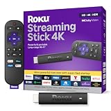
- Stunning 4K and Dolby Vision streaming made simple: With America’s number 1 TV streaming platform,* exploring popular apps—plus tons of free movies, shows, and live TV—is as easy as it is fun. *Based on hours streamed—Hypothesis Group
- Breathtaking picture quality: Stunningly sharp 4K picture brings out rich detail in your entertainment with four times the resolution of HD. Watch as colors pop off your screen and enjoy lifelike clarity with Dolby Vision and HDR10+.
- Seamless streaming for any room: With Roku Streaming Stick 4K, watch your favorite entertainment on any TV in the house, even in rooms farther from your router thanks to the long-range Wi-Fi receiver.
- Shows on the go: Take your TV to-go when traveling—without needing to log into someone else’s device.
- Compact without compromises: Our sleek design won’t block neighboring HDMI ports, so you can switch from streaming to gaming with ease. Plus, it’s designed to stay hidden behind your TV, keeping wires neatly out of sight
Why rain does not map neatly to hurricane category
Rainfall is shaped by storm speed and size, plus local geography and the interaction with surrounding weather. A weaker tropical cyclone can produce exceptional rain, while a stronger but fast-moving system may deliver less total rainfall at a particular point. Forecast rainfall totals and flood warnings are therefore more useful than the hurricane category for inland decisions.
Outdated Drivers Are Slowing You Down
One free scan finds every outdated or missing driver and matches the right update for your exact hardware.Free scan · exact hardware matchPC Slower Than It Used to Be?
A free scan shows the junk files, broken settings and background clutter dragging Windows down - then fixes them in one click.Free scan · Windows 10 & 11Wind hazards extend beyond the eyewall and coast
Hurricane-force wind means sustained wind of at least 74 mph. Such winds can damage roofs, power systems and trees and can turn unsecured objects into debris. Dangerous tropical-storm-force winds occur below that threshold and can still make travel, emergency response and outdoor sheltering unsafe.
The strongest winds are not the only consideration. A storm’s wind field may be broad, and different quadrants can affect different communities as the center passes. Gusts can exceed the sustained wind value. Terrain and buildings can channel or accelerate wind, while weakened trees and structures can fail after hours of exposure.
Wind impacts can reach well inland. Distance from the coast reduces surge exposure for many residents but does not automatically remove the threat from wind, falling trees, power outages or debris. Follow local wind advisories and shelter guidance rather than assuming that an inland location is protected.
Independent reader supportYour contribution helps us test, update, and keep practical guides available for everyone.Rip currents, surf and tornadoes create additional threats
Rip currents and surf
Long-period swells generated by a distant cyclone can reach beaches before the storm arrives and can continue after it passes. Rip currents may be powerful even when local weather appears manageable. Coastal visitors should obey beach closures and lifeguard instructions and avoid entering rough water during a tropical-cyclone event.
What’s actually slowing this PC down?
Pick the symptom - the matching free tool is one click away.
Best Value

- The Google TV Streamer (4K) delivers your favorite entertainment quickly, easily, and personalized to you[1,2]
- HDMI 2.1 cable required (sold separately)
- See movies and TV shows from all your services right from your home screen[2]; and find new things to watch with tailored recommendations for everyone in your home based on their interests and viewing habits
- Watch live TV and access over 800 free channels from Pluto TV, Tubi, and more[3]; if you find an interesting show or movie on your TV, mobile app, or Google search, you can easily add it to your watchlist, so it’s ready when you are[2]
- Up to 4K HDR with Dolby Vision delivers captivating, true-to-life detail[4]; and you can connect speakers that support Dolby Atmos for more immersive 3D sound
Tornadoes
Tornadoes are among the hazards associated with hurricanes, particularly in rainbands and areas where the storm interacts with land. They can form quickly and affect locations far from the center. A hurricane warning does not replace a tornado warning; use a weather-alert source that delivers both and move to the locally designated safe interior space when instructed.
How to compare a named “megastorm” with a hurricane responsibly
When a news report uses “megastorm,” replace the adjective with measurable questions. The answers determine risk more reliably than the label.
- What is the current classification and sustained wind? Check the latest NHC advisory for the storm’s official status and maximum sustained wind.
- How large is the wind field? Look for the extent of tropical-storm-force and hurricane-force winds, not just the maximum near the center.
- How fast is the system moving? A slow storm can prolong rain and wind; a faster storm can still produce severe effects but over a shorter period.
- What is the surge forecast for the specific coastline? Consider predicted inundation, the coastline shape and tide timing. Do not substitute a category for a surge forecast.
- What rainfall and river forecasts apply to your watershed? Inland flood risk depends on terrain, drainage and upstream rainfall as well as the cyclone’s strength.
- What secondary hazards are forecast? Check rip-current, surf, tornado, flash-flood and high-wind products separately.
- What instructions apply at your address? Local emergency managers determine evacuation zones, shelter openings, road closures and protective actions.
This approach allows a fair comparison between any two storms without implying that a storm called a megastorm must exceed a hurricane in every dimension.
Warnings, watches and the action a reader should take
Storm surge warning
The NHC defines a storm surge warning as a danger of life-threatening inundation, generally within 36 hours. It is an urgent protective-action message, not a prediction that every location in the warning area will experience the same depth of water.
Storm surge watch
A storm surge watch means life-threatening inundation is possible, generally within 48 hours. Conditions can change as the forecast track, intensity, size or timing changes.
How to use those products
- Read the current NHC advisory and the hazard graphics for the storm, rather than relying on an old headline.
- Check your local emergency-management agency for evacuation zones, deadlines, shelters and transportation instructions.
- If officials order an evacuation, leave promptly using the designated route; do not wait for the storm’s category to change.
- If you are not in an evacuation zone, prepare for the hazards forecast at your location, including wind, rain, power loss and blocked roads.
- Keep monitoring official updates because watches can become warnings and local conditions can deteriorate before the center arrives.
NHC warning lead times are general product definitions, not guaranteed preparation time. A forecast can change, roads can become impassable and local officials may issue earlier instructions for their communities.
Common mistakes caused by the megastorm label
- Assuming it is a higher category. There is no megastorm category above Category 5.
- Using peak wind as a total-damage score. Surge, rain, tornadoes and the storm’s size may dominate local consequences.
- Assuming inland means safe. Inland flooding, high winds, tornadoes and prolonged outages can be severe far from the shoreline.
- Comparing storms without comparing locations. The same cyclone can produce different effects because coastlines, terrain, infrastructure and tide timing differ.
- Waiting for certainty. Evacuation and shelter decisions should follow official instructions and the hazards forecast for your area, not a dramatic or reassuring adjective.
Bottom line: measure the hazards, not the headline
A hurricane is defined by a measurable threshold: at least 74 mph sustained surface wind in the NHC classification. A major hurricane begins at 111 mph. “Megastorm” has no comparable technical threshold; it is informal language for an unusually consequential or expansive storm. A hurricane may earn that description, but the description does not tell you its wind speed, size, rainfall, surge or local damage.
Use current NHC advisories, hazard-specific forecasts and local evacuation guidance. Surge and storm tide, inland flooding, wind, surf, rip currents and tornadoes each require their own assessment. The safest question is not “Is this a megastorm?” but “Which hazards are forecast at my location, and what are local officials telling me to do?”
Quick Recap
Product prices and availability are accurate as of the date/time indicated and are subject to change. Any price and availability information displayed on Amazon at the time of purchase will apply.






Say something about this film