Some links on this page are affiliate links: if you buy through them we may earn a commission, at no extra cost to you.
Called “one thousand and four hundred miles from anywhere”, the point of inaccessibility was discovered in 1992 by a Croatian-Canadian survey engineer. Hrvoje Lukatela wanted to find the place furthest from land, so he used a 3D model and a geospatial computer program to find the place. And no, it is not called after the Disney movie “Finding Nemo”. Although, that would be awesome, as Hrvoje actually found Nemo.
His logic was that because Earth is three dimensional, the most remote ocean point should be located in a point that is same distance away from the three nearest coastlines. Lukatela gave the name Nemo to the point, as a tribute to Captain Nemo, a fictional character in the novel “Twenty thousand leagues under the sea” by Jules Verne.

What is Point Nemo?
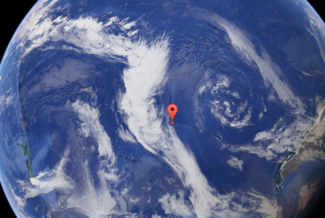
Point Nemo is not a land. The point is just a spot in the ocean that is positioned furthest from the land in any direction. Point Nemo is exactly 2 688 220.580 meters or 1450 nautical miles away from the following coastline points: Ducie Island in the South Pacific, Maher Island in Antarctica, and Motu Nui, Easter Island in the South Pacific.
Windows Errors? Fix Them Before They Spread
Repair common Windows errors and clear accumulated junk for a smoother, more stable PC - no reinstall needed.Free scan · no reinstallCrashes, No Sound, or Screen Glitches?
Random freezes, missing sound and display glitches usually trace back to one bad driver. Find and replace yours safely.Free scan · under a minuteDucie Island is a small atoll with only two kilometers diameter. The crew of Pandora was the first European crew to visit the Island. Motu Nui is just 100 meters across of Easter Island. The first European to visit was Jakob Roggeveen on Easter of 1722. A 20 kilometer wide volcanic island, Motu Nui is known for the giant stone monolith statutes on the coastline. Finally, Maher island is another small island which is connected to the Antarctica by the Getz Ice Shelf.
Popular on Amazon

- FOLDED EDITION - portable 8x10 inch folded size
- WORLD MAP is printed on 24lb paper
- 3D SHADED RELIEF: 3D shaded visual terrain relief for land and oceans
- PERFECT world map for business, home or educational use
- UP-TO-DATE: completely current world wall map poster
Five Quick Facts
Here are some interesting facts about Point Nemo:
– Another name used for the most remote point in the ocean is “Pole of Inaccessability”
– The land close to the point, or Ducie Island is non-inhabited, and by the time you get to Nemo, you’d wish you never bothered
Also popular on Amazon
- Updated
- Each Poster 18" tall x 29" wide
- High-quality 3 MIL lamination for added durability
- Tear Resistant
– If you somehow pass Point Nemo, you’ll closer to the International Space Station by 400km in space, which is closer than human will ever be
The Tool Desk
Outbyte PC Repair FREEClear out junk files and repair common Windows errorsFree Scan →Outbyte Driver Updater FREEFix the driver behind crashes, sound loss and screen glitchesFind Drivers →– In Latin, the name Nemo translates to “no-man”, which is basically what the area is
Also popular on Amazon
- Laminated Blank World Map Outline Poster - 18" x 29"
– If you want to visit, the directions are 48°52.6′ south and 123°23.6′ west.
Space Agencies and Nemo
Point Nemo is known also as “South Pacific Ocean Uninhabited Area” to space agencies. For years, Point Nemo has been used as a dumping ground. Some of the agencies using Nemo as dumping ground are Russian, Japanese and European agencies. The reason is because the point has fewest human inhabitants and the quietest shipping routes.
Also popular on Amazon
- LAMINATED UV Coating for Dry-Erase + Durability
- WORLD MAP is printed on 24lb paper
- 3D SHADED RELIEF: 3D shaded visual terrain relief for land and oceans
- PERFECT world map for business, home or educational use
- UP-TO-DATE: completely current world wall map poster
By now, more than a hundred decommissioned spacecraft have been dumped into the area. Satellites, cargo ships, and even space stations have found their way to Nemo.
Small fragments of space parts burn up in the atmosphere. However, parts like fuel tanks, pressure vehicles and other parts of the fuel system can survive the atmospheric re-entry. These end up in the ocean, and Point Nemo is the perfect place for dumping. Experts calm that there is no hazard to the aquatic level. Since there is no residual fuel that leaks out, these space parts are safe for the aquatic life. And the fun part is, similar as shipwrecks, space parts also create habitats that can be colonized by sea creatures. For years, there have been rumors about what lives inside Point Nemo, but nothing has been proven yet.
Quick Recap
Also popular on Amazon
Product prices and availability are accurate as of the date/time indicated and are subject to change. Any price and availability information displayed on Amazon at the time of purchase will apply.
Independent reader supportYour contribution helps us test, update, and keep practical guides available for everyone.





Say something about this film